Severe Thunderstorms, Isolated Tornado Risk in Alabama
In a Facebook post, Josh Johnson of WSFA in Montgomery, Alabama, commented:
Last Week: Coat – This Week: Boat
I think that is how all Alabamians feel right now. The National Weather Service in Birmingham said, “waves of heavy rain and thunderstorms will continue to move across the area through Saturday.

Thursday Severe Weather Threat
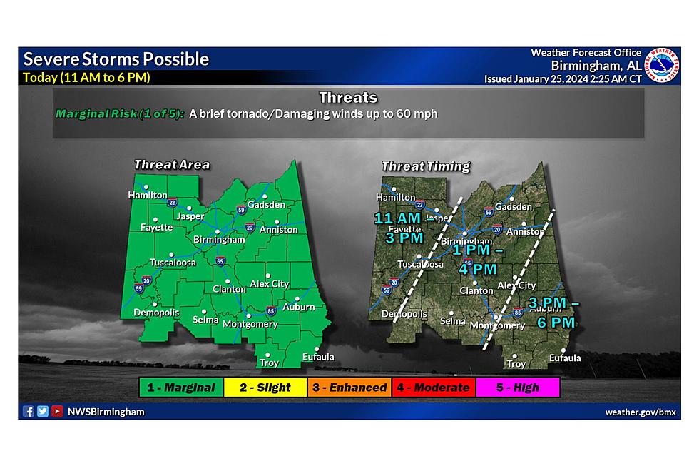
The Storm Prediction Center has a “Marginal Risk” for severe thunderstorms for nearly all of Alabama except a small far northwest section.
Threats
James Spann, ABC 33/40, and Townsquare Media Tuscaloosa Chief Meteorologist, said, “Heavier storms today will be capable of producing strong, gusty winds. The chance of an isolated tornado is low but not zero. The main window for stronger thunderstorms will come during the afternoon and evening hours.”
Timing
The overall threat timing is from 11 a.m. until 6 p.m. The Townsquare Media Coverage Area is between 11 a.m. and 3 p.m., with some counties between 1 p.m. and 4 p.m. Our coverage area includes Bibb, Fayette, Greene, Hale, Lamar, Perry, Pickens, Sumter, Tuscaloosa, and Walker counties.

Friday Outlook
“Occasional rain is likely again tomorrow, mainly over the southern 2/3 of the state. Temperatures will stay mild today and tomorrow with highs in the 67-73 degree range,” said Spann.
Thoughts on Saturday
Saturday includes the possibility of severe weather. The National Weather Service in Birmingham said, "Some of those storms could also become strong to severe, especially for areas near and east of I-65.”
"SPC has defined a "slight risk" (level 2/5) of severe thunderstorms for parts of East and South Alabama, in a broad zone from Anniston to Evergreen. A "marginal risk" (level 1/5) runs in the general area from Fort Payne to Mobile," said Spann.
In addition, there could be an extra 2 to 3 inches of rainfall, with some areas experiencing even higher amounts, until Saturday. As a result, there is an ongoing risk of flooding due to the rain falling on already saturated soils.
The Townsquare Media Weather Center will continue to monitor these developing weather scenarios.
Severe Weather Terminology You Should Know
Things To Have Before It Rains
Tips to Help Keep Alabama’s Furry Friends Safe this Winter
Gallery Credit: Mary K
Understanding Various Types of Winter Weather Alerts in Alabama
Gallery Credit: Mary K
Ways to Receive Severe Weather Information
More From 95.3 The Bear


