Hazardous Weather Outlook for Portions of Alabama
The Townsquare Media Weather Center has been monitoring conditions for our listening coverage area.
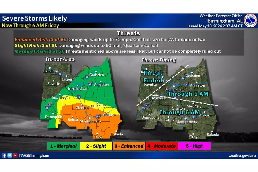
The National Weather Service in Birmingham has our area under a “Hazardous Weather Outlook” during this second wave of severe weather.

There have been multiple rounds of showers and storms ahead of a cold front. “Severe storms will be possible, with threats including damaging winds up to 60 mph, large hail, and a tornado or two,” said the National Weather Service in Birmingham.
Currently, the NWS reports that the "threat has ended for the northwest portions of the area. The greatest threat of severe storms continues in the Enhanced risk area where storms could produce damaging wind gusts and large hail."
Severe Thunderstorm Watch Info
There is a Severe Thunderstorm Watch until Friday, May 10 at 5 a.m. In the Townsquare Media coverage area, it impacts Perry County.
Perry County was removed at 3:16 a.m.
The other counties under the Severe Thunderstorm Watch includes:
Autauga - removed at 3:16 a.m.
Barbour
Bullock
Chilton - removed at 3:16 a.m.
Dallas - removed at 3:16 a.m.
Elmore
Lowndes - removed at 3:16 a.m.
Macon
Montgomery
Pike
Russell
Townsquare Media will continue with updates in the event that the weather changes, and should be on-air with coverage on any of our stations if coverage is needed.
LOOK: See how much gasoline cost the year you started driving
Gallery Credit: Sophia Crisafulli
See the Must-Drive Roads in Every State
Gallery Credit: Sarah Jones
RANKED: Here are the most popular national parks
Gallery Credit: Hannah Lang
LOOK: Oldest Disneyland Rides From 1955 to Today
Gallery Credit: Angela Brown
LOOK: Route 66’s quirkiest and most wonderful attractions state by state
Gallery Credit: Kery Wiginton
LOOK: Stunning vintage photos capture the beauty of America's national parks
Gallery Credit: Alexander Raeburn
LET'S GO: The most popular historic sites in America
More From 95.3 The Bear