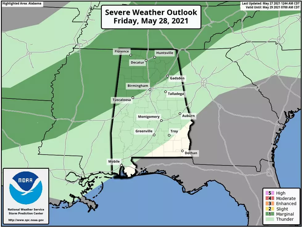
Marginal Severe Weather Risk for Portions of Alabama on Friday
The Midwest and the Plains have been hit with tornadoes, damaging winds, and large hail. These areas are preparing for another round today. There were “355 reports of damaging winds, large hail, and tornadoes in the 24 hours by the Storm Prediction Center.” According to the Weather Channel, “that's the second-highest total for any 24-hour period in SPC's database so far in 2021.”
Today, Thursday, May 27, 2021, you can expect a high in the mid-80s, a mix of sun and clouds, and the potential for scattered showers or storms this afternoon into the evening.
On Friday, May 28, 2021, the weather outlook has portions of Alabama under a "marginal risk" (level 1/5) from the Storm Prediction Center. The areas of concern are along and north of I-59.
James Spann, ABC 33/40, and Townsquare Media Tuscaloosa Chief Meteorologist notes that Coverage of scattered showers and storms will be higher tomorrow afternoon and tomorrow night as a cold front approaches the state and some of the storms could be strong.
In addition, James Spann lets us know that “heavier thunderstorms could produce gusty winds and small hail; most of the storms will come from about 1:00 pm until 10:00 p.m. The high tomorrow will be in the low to mid-80s with the sky occasionally cloudy.”
Townsquare Media will be closely monitoring this developing weather system. Please be sure to stay weather aware, as weather information can change due to emerging conditions. As always, have a way to receive weather information. A great resource is our free app.

(Source) Click here to follow the Facebook Page for James Spann. Click here for more from the Weather Channel.
Severe Weather Terminology You Should Know
Ways to Receive Severe Weather Information
KEEP READING: Get answers to 51 of the most frequently asked weather questions...
More From 95.3 The Bear


![[Video] Central And West Alabama Impacted By Storms Tuesday Evening](http://townsquare.media/site/993/files/2022/03/attachment-IMG_3468.jpeg?w=980&q=75)