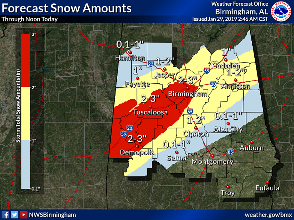
Tuscaloosa Could Receive Two to Three Inches of Snow Today
The latest forecast from the National Weather Service suggests Tuscaloosa is on track to receive the greatest amount of snowfall from the upcoming winter storm.
Many counties have been downgraded from a Winter Storm Warning to a Winter Storm Watch. Tuscaloosa County is still in the Winter Storm Warning, as snowfall could reach two to three inches along the I 20/59 corridor.
Rain is anticipated to change to snow within the upcoming hours, and snowfall will continue for several hours. The National Weather Service believes snow could fall as quickly as an inch an hour. The text of the latest Winter Storm Warning is below.
.Snow will continue across Northwest Alabama this morning with
rain changing to snow through the morning hours from northwest to
southeast. Snow will come to an end around noon today in the
East. While snow may fall for only one to three hours at a given
location, it could be heavy at times, with accumulations up to two
and a half inches in the warning area. Amounts under two inches
are expected in the advisory area. Temperatures will fall below
freezing across the warning area and portions of the advisory
area, resulting in potentially dangerous travel conditions. This
will impact the morning commute especially along the Interstate 20
corridor.

ALZ022>025-030>034-039-291800-
/O.CON.KBMX.WS.W.0001.000000T0000Z-190129T1800Z/
Pickens-Tuscaloosa-Jefferson-Shelby-Sumter-Greene-Hale-Perry-Bibb-
Marengo-
Including the cities of Carrollton, Tuscaloosa, Birmingham,
Hoover, Columbiana, Pelham, Alabaster, Livingston, Eutaw,
Greensboro, Moundville, Marion, Centreville, Demopolis,
and Linden
225 AM CST Tue Jan 29 2019

...WINTER STORM WARNING REMAINS IN EFFECT UNTIL NOON CST TODAY...

* WHAT...Heavy snow expected at times. Total snow accumulations of
  up to two and a half inches.

* WHERE...Portions of Central Alabama near the I-20 corridor from
  the Mississippi state line to the Birmingham metro area.

* WHEN...From midnight tonight to noon CST Tuesday. The heaviest
  activity will only last 2 to 3 hours.

* ADDITIONAL DETAILS...Plan on dangerous, slick road conditions
  at times. The hazardous conditions could impact the morning
  commute.

PRECAUTIONARY/PREPAREDNESS ACTIONS...

A Winter Storm Warning for snow means severe winter weather
conditions will make travel very hazardous or impossible. If you
must travel, keep an extra flashlight, food and water in your
vehicle in case of an emergency.

The latest road conditions for the state you are calling from can
be obtained by calling 5 1 1.
More From 95.3 The Bear