
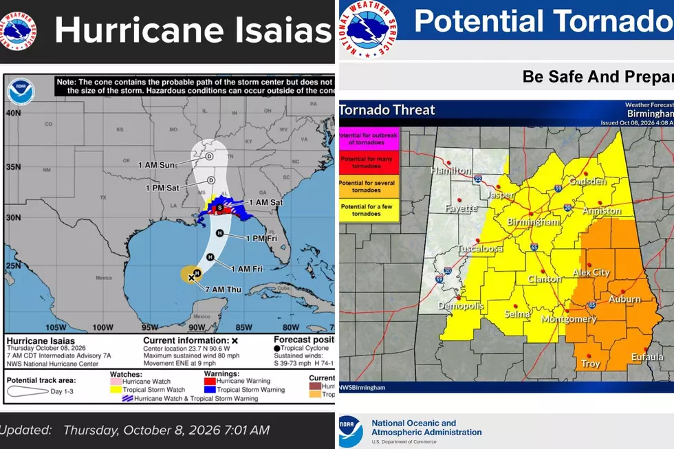
Isaias Is Now a Hurricane: West Alabama and Gameday Outlook
Isaias is now a hurricane and is forecast to reach at least Category 2 strength as it moves through the central Gulf and begins turning more north. The latest information from NOAA Hurricane Hunters indicates that Isaias continues to intensify.
Isaias Stats
- The system is moving along an east-northeast track
- The speed of the system's movement is 9 mph
- Estimated minimum central pressure is 979 mb
- Landfall Friday evening, October 9

Forecaster Note: I encourage you to stay up to date with the latest information through Saturday. As Isaias continues along its track, the forecast and system details could change, affecting what we can expect in West Alabama.
Possible West Alabama Impacts
The National Weather Service in Birmingham said that impacts will include “heavy rainfall, gusty winds, and isolated tornadoes from Friday Night into Saturday.”
Widespread heavy rainfall could raise flash-flood concerns across our area.
The Townsquare Media Weather Center is monitoring the projected track of Isaias and where West Alabama counties could be located as the storms move through Alabama.
This is important because the area east of the storm’s center track can be more favorable for spin-up tornadoes, making the storm’s path especially important for West Alabama.
Tornado Threat
“Isolated tornadoes are possible along and east of the track,” said James Spann, Alabama Weather Network Chief Meteorologist. “The risk Friday night is from Baldwin and Escambia counties east to Dothan in Alabama, and the western Florida Panhandle. On Saturday, a few tornadoes are possible over the eastern half of Alabama. The tornado threat over the western half of the state is very low.”
Some West Alabama counties are currently under a “potential for a few tornadoes,” including Bibb, much of Hale, Perry, and part of Tuscaloosa County, said the National Weather Service in Birmingham.

National Hurricane Center Key Messages
- Isaias is expected to strengthen and be a strong hurricane when it approaches the northern Gulf Coast on Friday.
- A life-threatening storm surge is expected along a portion of the northern Gulf Coast, and a Storm Surge Warning remains in effect from the Mouth of the Mississippi River to Steinhatchee, Florida.
- Residents in the warning area should follow advice given by local officials and evacuate if told to do so.
- Damaging hurricane force-winds are expected over portions of the Florida Panhandle, southern Alabama, and southern Mississippi, and a Hurricane Warning remains in effect from Ocean Springs, Mississippi to the Bay/Gulf County Line, Florida.
- Residents in these areas should prepare for the possibility of long-duration power outages.
- Isaias will bring areas of heavy rainfall to the central U.S. Gulf coast and much of the Southeast Friday into the weekend.
- Flash and urban flooding, along with isolated river flooding, will be possible

Alabama/Georgia Weather Outlook
Spann said, “The weather looks favorable for Saturday night's Alabama/Georgia game at Bryant-Denny Stadium in Tuscaloosa (6:30 p.m. CT kickoff). Lingering clouds, an outside risk of a passing shower or two, and winds less than 15 mph.”
Amazing and Intriguing Weather Folklore
Gallery Credit: Mary K
Signs of a Bad Winter According to Weather Folklore
Gallery Credit: Mary K
Clouds: Artwork In The Sky