Alabamians Watch Closely as Ian Intensifies Aiming for Florida
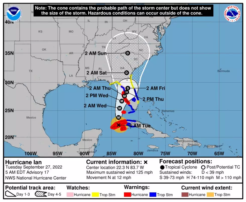
Hurricane Ian is now at a category level 3, which is considered a major hurricane on the Saffir-Simpson hurricane wind scale. Currently, Ian winds are up to 125 miles per hour and over the western tip of Cuba.

Forecaster Note: Please remember that information on Ian and its impacts could change due to the nature of the system. Townsquare Media is closely monitoring Ian and what it could mean for Alabamians. We are on duty to bring you all the necessary updates. – Mary K.
Ian will then cross into the southeast Gulf of Mexico and the path is still trending eastward. This means that the center of the cone could come close to the Tampa, St. Pete, and Clearwater area roughly around Wednesday night.
“This could bring the powerful eyewall through all three cities while pushing dangerous storm surge water straight into Tampa Bay and other river systems to the south,” said The Weather Channel.

There are Still Some Forecast Uncertainties
The Weather Channel reports, that “if Ian curls sharper toward the east, that could bring it ashore somewhere along the western Florida Peninsula as soon as late Wednesday. If, however, it continues in a more northerly direction, its center may not come ashore in the panhandle until late Thursday.”
The National Weather Service in Birmingham said that “the forecast track of Ian's center has ever so slightly shifted eastward over the last 12 hours. As Ian moves northward into Florida and southern Georgia by late Friday and into Saturday the structure is forecast to quickly as it interacts with nearby weather features.”
Also, “we could still be looking at an axis of heavy rain that develops on the northwest side of the circulation,” the National Weather Service in Birmingham. “If this occurs, the track of Ian's center during this time will determine whether or not the band of heavy rain nudges into Alabama or stays farther east over Georgia.”
Could Ian Become a Category 4 Hurricane?
It is predicted that Ian will gain even more strength and intensification even reaching category 4. Then, as Ian draws closer to Florida, the thought process is that Ian will start to move slower with an expanded wind field. This brings even more concern for enhanced impacts.

Alabamians Watching Ian
James Spann, ABC 33/40, and Townsquare Media Tuscaloosa Chief Meteorologist said that “Alabama and the Central Gulf Coast (Gulf Shores to Panama City Beach) will be on the dry, offshore flow side of the circulation (the west side with a north wind). Some rain is certainly possible for places like Destin and Panama City Beach Friday, but the weather won’t be dangerous there.”
Central Gulf Coast
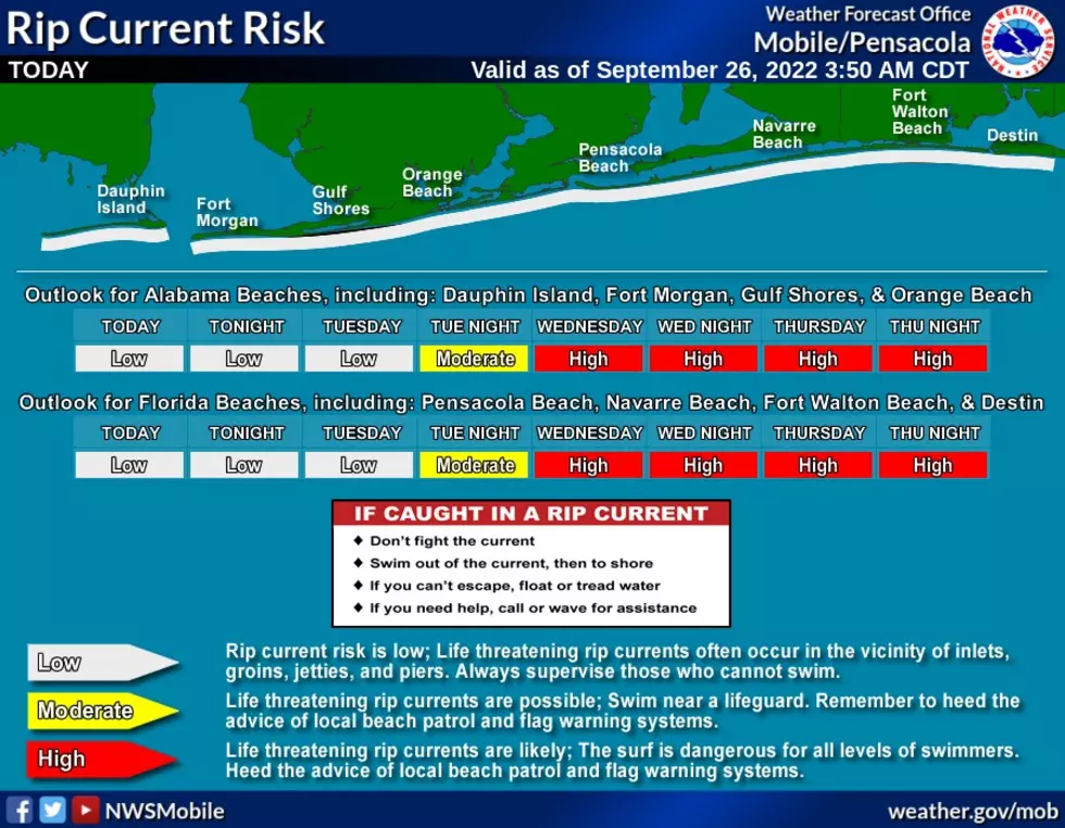
There is a concern of very rough surf and dangerous high rip current for Gulf Shores to Panama City Beach.
Alabama Long Term
“Alabama could see some rain from the remnants of the system by Friday night and Saturday,” said Spann. “For now it looks like the best chance of rain will be over the eastern half of the state; this means some risk of rain for the Auburn/LSU game, and race activities at Talladega Saturday. Sunday looks mostly dry statewide with only a few stray showers. Confidence in the weekend forecast remains low due to high uncertainty.”

National Weather Service Birmingham Highlights
Tornado:
No risk at this time due to our expected position on the west side of Ian's circulation, a less-than-favorable area for tornadoes.
Wind:
What: Potential for sustained winds upwards of 20 mph and gusts upwards of 35 mph
Where: Mainly near the Interstate 85 corridor
When: Thursday into early Saturday
Flooding:
What: Potential for localized flooding
Where: Far eastern areas of Central Alabama, especially toward the Alabama/Georgia state line
When: Friday into Saturday

(Source) For more from The Weather Channel, click here. Click here to follow the Facebook Page for James Spann. For more details from the National Weather Service in Birmingham, click here.
LOOK: The most expensive weather and climate disasters in recent decades
Farmer’s Almanac United States 2022 – 2023 Winter Outlook
2022 Atlantic Hurricane Season Names
More From 95.3 The Bear