Portions of West Alabama Upgraded to Moderate Severe Weather Risk
The Storm Prediction Center is updating its severe weather outlook for our area.
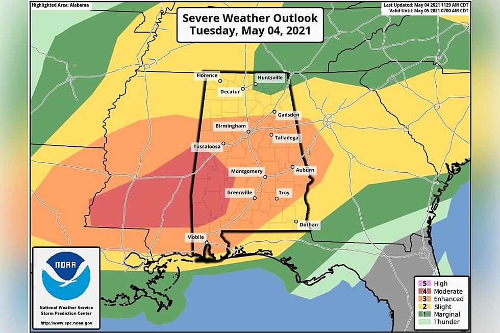
As of about 11:30 a.m. Tuesday, portions of Greene, Hale and Pickens Counties have been upgraded from an enhanced risk (level 3/5) to a moderate risk (level 4/5). The moderate risk, according to the National Weather Service, indicates that serious storms are likely and they are prone to be "long-lived, widespread and intense."
Residents in these areas, and all communities eastward of these areas, should stay weather aware all day. Townsquare Media Tuscaloosa and ABC 33/40's Chief Meteorologist James Spann says that the main concerns for today and early tonight include damaging winds, though isolated tornadoes are possible.
Stay up-to-date with all severe weather information right here.
Townsquare Media Tuscaloosa's Operation Storm Watch is brought to you by Safe-T Shelter. Visit their website here to see their selection of residential and commercial safe rooms and storm shelters. To contact a Safe-T Shelter representative, click here to visit their Facebook page.

Check out the latest radar models here:
If a tornado warning is issued in our area, Townsquare Media Tuscaloosa Operation Storm Watch will provide you with live and local team coverage, including wall-to-wall weather with James Spann.
To view the latest weather updates and information, click here.
TIPS: Here’s how you can prepare for power outages
KEEP READING: What to do after a tornado strikes
KEEP READING: Get answers to 51 of the most frequently asked weather questions...
More From 95.3 The Bear