Ice Storm Warning Issued for Portions of West Alabama
The National Weather Service in Birmingham has issued an ICE STORM WARNING in effect until 9 p.m. tonight. The text of the warning is as follows:

Get our free mobile app
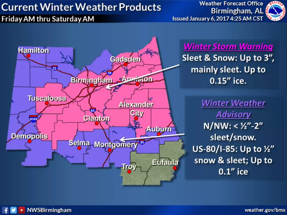
Including the cities of Hamilton, Sulligent, Vernon, Fayette,
Double Springs, and Carrollton
349 AM CST Mon Feb 15 2021

...ICE STORM WARNING IN EFFECT UNTIL 9 PM CST THIS EVENING...
...WIND CHILL ADVISORY IN EFFECT FROM MIDNIGHT TONIGHT TO 9 AM
CST TUESDAY...

* WHAT...For the Ice Storm Warning, significant icing. Storm total
  ice accumulations of quarter to a half inch. Light sleet and
  snow accumulations up to a half inch. For the Wind Chill
  Advisory, very cold wind chills expected. Wind chills as low as
  5 below zero.

* WHERE...Marion, Lamar, Fayette, Winston and Pickens Counties.

* WHEN...For the Ice Storm Warning, until 9 PM CST this evening.
  For the Wind Chill Advisory, from midnight tonight to 9 AM CST
  Tuesday.

* IMPACTS...Power outages and tree damage are likely due to the
  ice. Travel could be nearly impossible. The hazardous conditions
  will impact the morning and evening commute. The cold wind
  chills could result in hypothermia if precautions are not taken.


PRECAUTIONARY/PREPAREDNESS ACTIONS...

Travel is strongly discouraged. If you must travel, keep an extra
flashlight, food and water in your vehicle in case of an
emergency. Prepare for possible power outages.

Use caution while traveling outside. Wear appropriate clothing, a
hat, and gloves.
TIPS: Here's how you can prepare for power outages
More From 95.3 The Bear