What You Need to Know About the Winter Storm Impacting Alabama
Wintry precipitation is impacting Central Alabama's far northwest regions as the Arctic front moves eastward. Throughout today and tonight, the wintry mix is anticipated to spread southeastward, with the weather event expected to conclude in the southeast by early tomorrow morning.
READ MORE: Winter Weather Advisory for Portions of Alabama
What to Expect Next
Alabamians should prepare for dangerously cold temperatures throughout the middle of the week. Also, we are closely monitoring another potential surge of cold conditions this weekend.
READ MORE: Temps Plunge into the Teens: Hard Freeze for Parts of Alabama
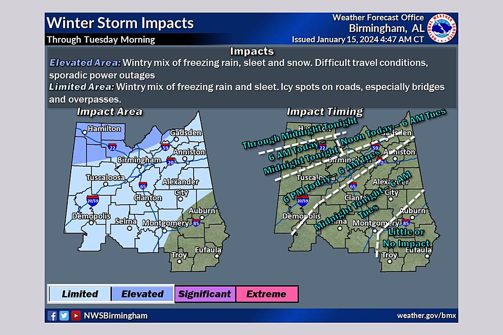
National Weather Service in Birmingham Wintry Precipitation Highlights
Where: All but the far southeast part of Central Alabama.
When: Continuing in the far northwest this morning, and spreading slowly southward today through tonight. Wintry mix will end by early Tuesday morning in the south.
Threats: A wintry mix of snow, sleet, and freezing rain in the Winter Storm Warning area. Light amounts of sleet or freezing rain in the Winter Weather Advisory area (Even small amounts of freezing rain accumulation can lead to travel impacts).
Impacts: Potential for slippery roads due to accumulations of ice or snow. Hazardous travel, most likely in the far north.
READ MORE: Winter in Alabama: What Type of Precipitation You Can Expect
James Spann, ABC 33/40, and Townsquare Media Tuscaloosa Chief Meteorologist said, "The Arctic front drops southward, and temperatures go below freezing over the winter weather advisory area late this afternoon and tonight. As light freezing rain and drizzle falls, bridges will become icy. Some blacktop road surfaces will become icy.”
Bitterly Cold Temperature Review from the National Weather Service
Where: All of Central Alabama
When: Monday night through Thursday morning
Threats: A long-duration cold wave with a hard freeze; wind chill values as low as the single digits below zero.
Impacts: Exposed, non-insulated pipes will be at risk of bursting; risk of hypothermia for those with prolonged exposure to the cold.
Spann said that this “cold wave will be similar to December 2022. Lows will drop into the teens tomorrow and Wednesday morning, with single-digit lows likely over the northern third of the state early Wednesday.”
Dangerous Wind Chill Values
“Wind chill values will be very low, below zero at times tomorrow, tomorrow night, and early Wednesday. Temperatures reach the upper teens along the Gulf Coast Wednesday morning,” said Spann.
Energy-Saving Tips for Cold Weather
Gallery Credit: Mary K
Winter Precipitation You Can Expect in Alabama
Gallery Credit: Mary K
Cheapest Homes in Tuscaloosa County Alabama - November Edition
Gallery Credit: Mary K
Alabama’s Fastest-Growing Boomtown
Gallery Credit: Mary K
Top 10 Snobbiest Cities in Alabama
Gallery Credit: Mary K
More From 95.3 The Bear