If You Think Spring is Here… Not So Fast!
After a brutal run of cold weather, freezing rain, sleet and snow, it has been nice to get a big time shot of warm air. It has been like Mother Nature flipped a giant switch and it became spring around Tuscaloosa! No so fast!
I've noticed the birds have come back singing their hearts out and the weeds are on a bender trying to destroy my lawn. Hold the phone, winter want another punch!
We have a cold blast coming into the area tonight with a chance of a wintry mix of precipitation. I can hear you now saying, no way! Yes way. Just as you finally finished all that bread and milk, it may be time for another run.
According to a statement from the National Weather Service - Birmingham:
A WINTRY MIX OF RAIN...SNOW AND SLEET WILL BE POSSIBLE OVERNIGHT
ACROSS THE FAR NORTHERN COUNTIES OF CENTRAL ALABAMA. WHILE GROUND
TEMPERATURES REMAIN WARM...THERE IS A SMALL POTENTIAL TO SEE UP TO
ONE QUARTER OF AN INCH OF SNOW IN THE GRASS AND COLDER ELEVATED
AREAS ALONG AND NORTH OF A LINE FROM SULLIGENT...ONEONTA...TO
GADSDEN.
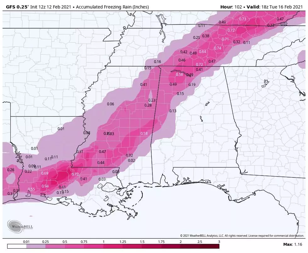
Here's the precipitation map for tonight:
The forecast for tomorrow (2/26):
Well, it appears we won't get slammed with a big time ice event. Even James Spann is calling for a cold rain around Tuscaloosa with a few flurries possible before moving out. But, it will be much colder for the couple of days. The daytime high will be in the 40s and down into the 20s at night. Good news, the forecast calls for the temperature to climb back into the 60s for the weekend. Then, the birds can get back to singing and the weeds can get back to being annoying.
Get more details on the forecast and see our interactive weather radar, by clicking here.
More From 95.3 The Bear